Hai Van Pass: The World’s 4th Most Beautiful Mountain Pass
Rising through the clouds, Hai Van Pass forms the natural border between Thua Thien Hue and Da Nang. Celebrated as “the most majestic pass in the world”, this winding mountain road drapes across the peaks like a silk ribbon, offering some of the most breathtaking views in Vietnam. More than a link between two cities, it is a journey in itself, where travelers pause at dramatic viewpoints and centuries-old relics that tell stories of the past. In this guide, you will uncover the history of Hai Van Pass and discover the unmissable stops along this magical road.
Written by Oliver PHUNG (Tour guide)
Updated on Oct 02, 2025
0 comment
Oliver Phung is a specialist in cultural tourism and trekking in the mountains of Northern Vietnam, with over 7 years of hands-on experience. Born and raised amidst the sounds of the kèn (a traditional instrument) and the songs of the Mông, Thái, Tay, and Dao ethnic communities, Oliver does not just have a passion for their history and culture, he lives it. For him, sharing the beauty of these traditions is not just a job, it's a way of life.
Drawing from his experience on hundreds of trekking trips and guided tours across routes from Ha Giang, Lao Cai to Cao Bang, Oliver offers an authentic and in-depth perspective.
The Hai Van Pass (Hải Vân, literally “Ocean Cloud”) is where the Annamite Range plunges dramatically into the South China Sea. This natural frontier divides the misty, cooler north (Hue) from the sunnier, warmer south (Da Nang). As you ride, the scenery shifts constantly: jungle-clad slopes, sweeping coastal views, and clouds drifting across the summit that transform the road into a surreal sea of white.
At the crest stands Hai Van Quan (Hai Van gate), the 19th-century imperial gate inscribed with “Thiên Hạ Đệ Nhất Hùng Quan” (“The World’s Most Marvelous Wonder”). Once the border between Đại Việt and Champa, later used as a French and American military outpost, it remains one of Vietnam’s most iconic landmarks. No wonder global media have praised it: the Guardian ranked it among the world’s most scenic coastal roads, while the BBC Top Gear Special (2008) immortalized its winding beauty.
How long is the Hai Van Pass?
The Hai Van Pass measures about 21 kilometers, reaching a summit of 496 meters above sea level. Though modest in size compared to other mountain passes, its dramatic curves and sweeping vistas make it unforgettable. A direct drive takes 45 minutes to 1 hour, but most travelers stretch it to two or three hours with stops for viewpoints, coffee, and photos at Hai Van Quan. In this sense, its “length” is experienced less in kilometers and more in the richness of landscapes and memories along the way.
A Little Bit of History
For centuries, the Hai Van Pass was more than a scenic road. It served as a frontier that shaped kingdoms and battles.
Champa and Đại Việt
In 1306, diplomacy rather than war reshaped this border. Princess Huyền Trân of Đại Việt married King Chế Mân (Jaya Sinhavarman III) of Champa. In return, Champa ceded the lands of Ô and Lý, which today cover Thừa Thiên Huế and Quảng Trị. The Hai Van Pass became the symbolic frontier of this transfer.
My Son Sanctuary, the remaining relic of the Champa Empire
The Nguyễn Dynasty
By the early 19th century, the Nguyễn dynasty recognized the pass’s strategic importance. In 1826, Emperor Minh Mạng ordered the construction of the stone fortress known as Hai Van Quan. Its bold inscription reads “Thiên Hạ Đệ Nhất Hùng Quan” or “The World’s Most Marvelous Wonder”. Today, Hai Van Quan is preserved as a national monument, and standing here offers not only sweeping views but also a sense of continuity with Vietnam’s imperial past.
Hai Van Pass under the Nguyen Dynasty
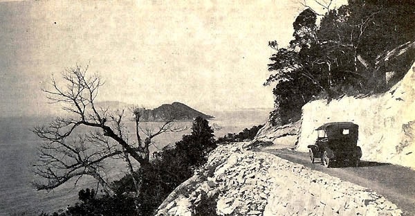
Colonial Period
During the French colonial period, the pass was reinforced with bunkers and military outposts. These installations guarded one of the most critical north–south corridors in central Vietnam. Though weathered by time, their ruins still dot the ridge, silent witnesses to an era when control of the Hai Van Mountain Pass meant control of movement between Huế and Đà Nẵng.
Hai Van Pass during the French colonial period was one of the important strongholds
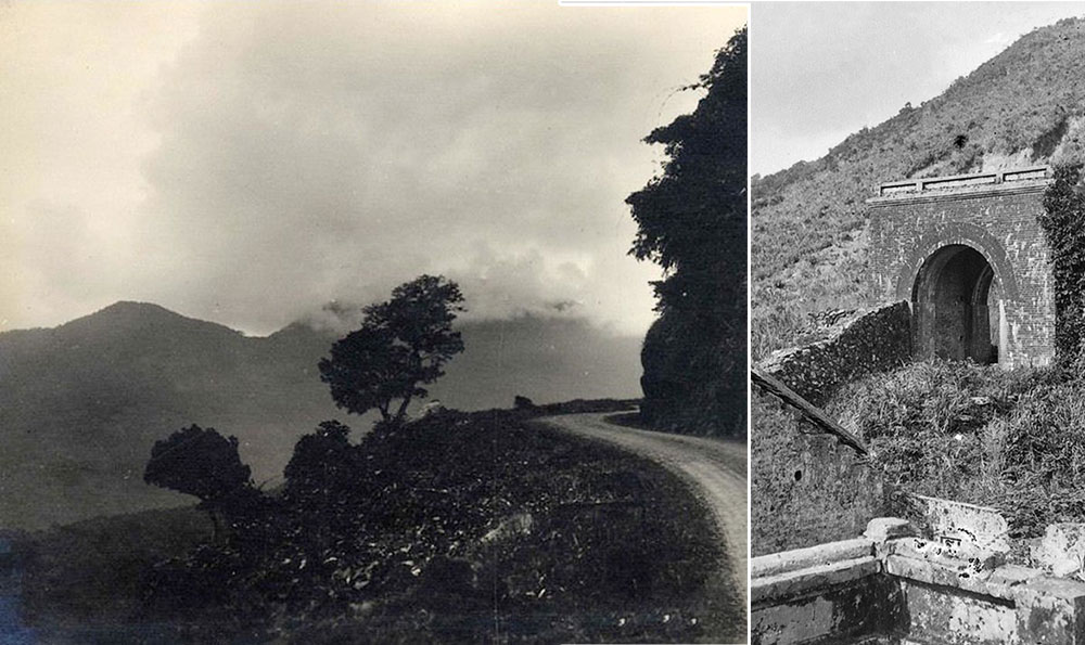
The 20th Century
In the mid-20th century, the Hai Van Mountain Pass again became a frontline. Both during the First Indochina War and the Vietnam War, it was remembered less for its beauty and more for its peril. French soldiers nicknamed it the “Route sans joie”, translated as “Street Without Joy”. Local resistance forces staged daring ambushes along the road and railway, using the steep terrain to their advantage. Today, visitors driving its curves encounter only mist and ocean views, but beneath them lie layers of history that shaped modern Vietnam.
Panorama of Hai Van Pass
How to Travel the Hai Van Pass
There are a few classic ways to conquer the Hai Van Pass, each offering a very different vibe. You could also mix it up. So, for example, ride a motorbike from Hue to Da Nang via the Hai Van Pass, then return to Hue by train through the Hai Van Tunnel. Here’s my take, with real costs, travel time, and what to watch out for.
🛵 Motorcycle
Who it’s for: Backpackers, adventurous couples, or anyone who wants the freedom of the open road.
Why it’s worth it: You feel every curve, every gust of wind, and can stop anywhere for a coffee or a photo.
Watch out for: Sudden rain and slippery bends. Only drive yourself if you have a valid license and are confident to do so. Otherwise, hop on an Easy Rider tour.
How long: 3–5 hours with stops.
How much: 80,000–250,000 VND/day (≈ 3–10 USD) for rental motorcyle; an d from 55–65 USD for an Easy Rider.
Hai Van Pass is a beautiful road to experience by motorbike
👉 My advice: Fill up before leaving Da Nang or Hue. Petrol stations are rare once you start climbing.
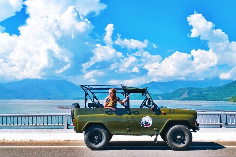
🚙 Car/Jeep
Who it’s for: Families, groups of friends, or anyone who prefers open-air comfort without riding.
Why it’s worth it: A vintage jeep ride with a driver who knows all the viewpoints. Stops usually include Hải Vân Quan, Turtle Rock, and Lăng Cô Bay.
Watch out for: It’s pricier than bikes or trains, and bumpy on some stretches.
How long: Full-day trips, often combined with Marble Mountains.
How much: 75–95 USD per jeep (2–4 people).
Jeep Tour allows you to comfortably breathe fresh air and sea
👉 My advice: Book early in high season. Jeeps get snapped up quickly, especially from Da Nang.
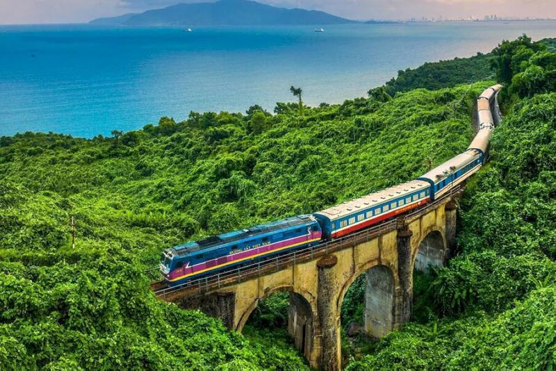
🚉 Train
Who it’s for: Travelers who prefer to sit back and enjoy the view.
Why it’s worth it: The train hugs the cliffs, with the South China Sea sparkling below. It offers a peaceful alternative to the adrenaline of motorbikes.
Watch out for: You can’t stop for photos, and the journey is slower than driving.
How long: 2.5–3 hours.
How much: 70,000–120,000 VND (≈ 3–5 USD).
The train is the most worthwhile route to fully experience the beauty of Hai Van Pass
👉 My advice: Sit on the left side when heading south (Hue → Da Nang) for the best sea views.
🚲 Bicycle
Who it’s for: Experienced cyclists who want a bucket-list challenge.
Why it’s worth it: Few things beat the pride of reaching the summit under your own power.
Watch out for: It’s a tough 21 km climb with nearly 500 m of elevation. Not for beginners.
How long: 4–8 hours, depending on fitness.
How much: 12–70 USD (bike rental vs guided cycling tour with support car).
👉 My advice: Start at sunrise to avoid the midday sun, and always carry extra water.
What to Do and See Along the Pass
Nam O
Nestled at the southern foot of the Hai Van Pass, Nam Ô Village has stood for more than 700 years, renowned for its traditional fish sauce craft. The beach is calm and sloping, especially magical during the moss season (February–April) when green carpets cover the rocks along the shore.
Nam O fishing village is enchantingly beautiful through the lens
Beyond swimming and photography, visitors can take a boat trip on the Cu De River, admire the French-built railway bridge, or chat with local fishermen. Nearby, you’ll also find the untouched Van Village and the majestic Hai Van Pass, making this area both culturally rich and naturally stunning.
Black Rock Beach
The first thing you’ll notice here are the huge dark boulders stacked up along the shore. That’s where the name Bãi Đá Đen (literally “Black Rock Beach”) comes from. Locals also call it “Obama Rock”. No, President Obama never came here — the nickname started out as a joke years ago, but it stuck and ended up making the place way more popular.
Black Rock Beach is still deserted and has few tourists
Even though it’s not right on the Hai Van Pass route, the trip usually kicks off from the foot of the pass. From a small pier in Lien Chieu District, you can hop on a local fisherman’s boat and enjoy a 15–20 minute ride on the water before you land at the rocks. It’s a fun little detour that feels off-the-beaten-path.
Once you get there, you can go for a swim, snorkel over the coral, set up a tent with friends, or just chill out on the rocks and watch the sun go down. The vibe is laid-back, a little wild, and perfect if you’re after something different from the usual city beaches.
Turtle Rock
If you’re chasing the best viewpoint on the Hai Van Pass, this might just be it. Perched high on the ridge, Turtle Rock gives you a sweeping 360° panorama over Da Nang, the Son Tra Peninsula, and the endless blue of the South China Sea.
It’s a spot where you really understand why people call Hai Van the “Ocean Cloud Pass.” On a clear day you’ll see the city skyline in the distance, the curve of the coastline, and mist drifting off the mountains. It’s dramatic, peaceful, and hands down one of the most Instagrammable stops on the pass.
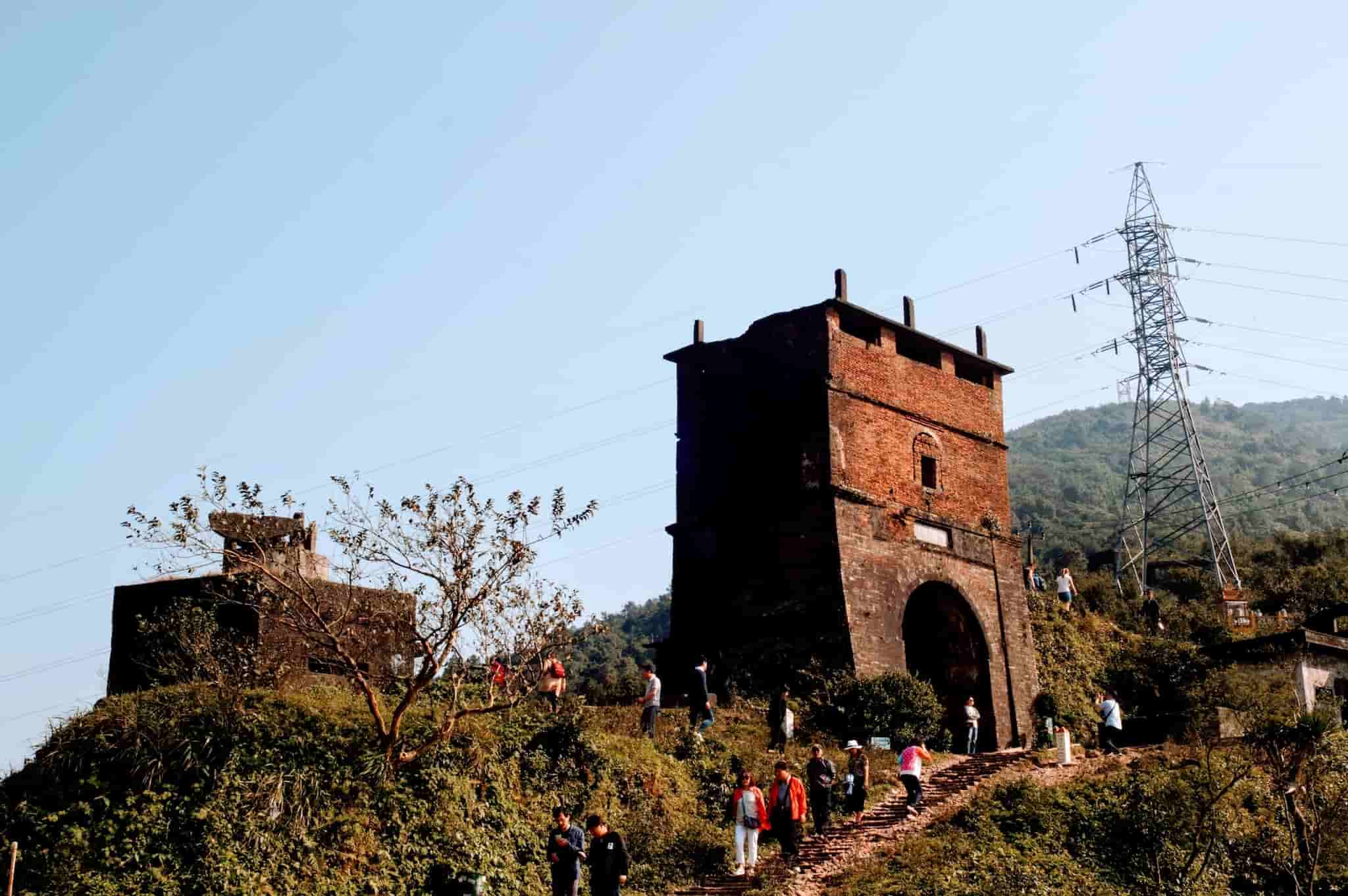
French defensive bunker
Right at the top of the Hai Van Pass, you’ll spot the ruins of a French bunker. Built to guard Da Nang’s coastline, it still stands strong with its stone walls and narrow rifle slits.
Climb up and you’ll get wide-open views; one side looks down to Da Nang, the other out to the East Sea and Lăng Cô Bay. The wind here is fierce, the vibe raw and dramatic.
Hai Van Quan gate
If there’s just one place every traveler should stop on the Hai Van Pass, it’s Hải Vân Quan. Sitting nearly 500 meters above sea level, this fortress doesn’t just tell stories of the past; it delivers one of the most stunning viewpoints in central Vietnam.
From the stone walls, you’ll capture panoramic shots of Da Nang’s coastline to the south and the curve of Lăng Cô Bay to the north. On misty days, clouds drift right through the gate, creating a dreamy backdrop for photos. On clear afternoons, it’s the perfect spot to pause for coffee, stretch your legs, and soak in the crisp mountain air.
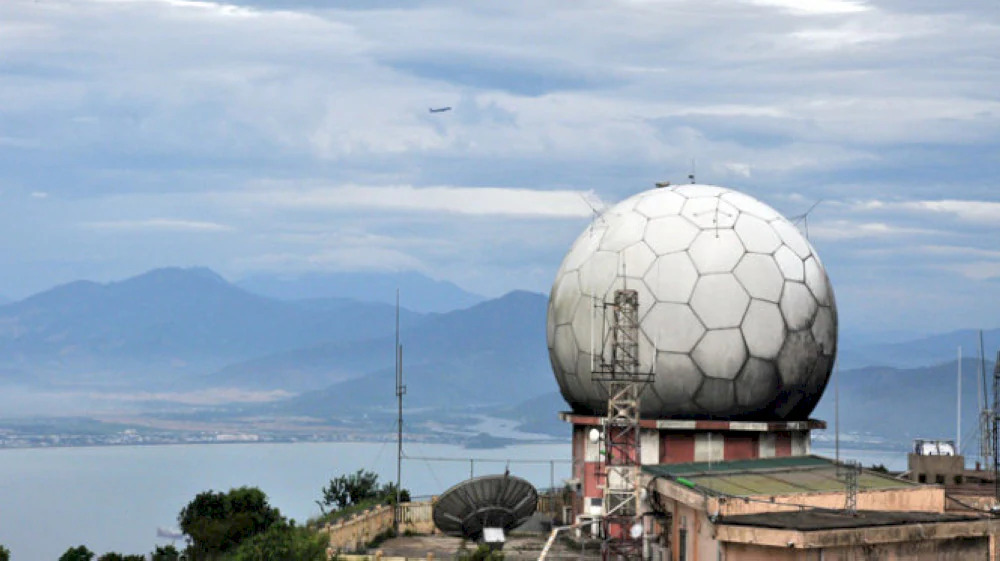
US Radar Station
Back in 1965, the U.S. military built this radar station, and it played a big role during the Vietnam War; tracking planes and keeping an eye on the East Sea. After the war and reunification, the Vietnamese army took over and renamed it Radar Station 29, still using it to watch over the skies.
These days, travelers mostly know it by its nickname, the “Eyes of Indochina.” You’ll see three giant white radar domes sitting on the mountaintop, visible from miles away. From up here you can see all of Da Nang, My Khe Beach, the Hai Van Pass, and even Lang Co Bay if the weather’s clear. Sometimes clouds roll right across the viewpoint, which makes it a favorite spot for cloud hunters, sunset lovers, and anyone with a camera.
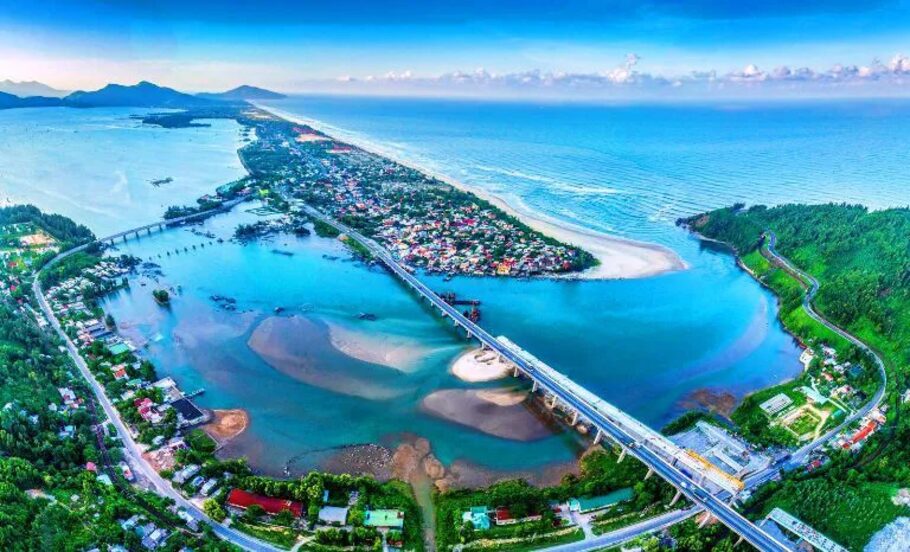
Lang Co Beach
Just north of the Hai Van Pass, Lang Co Bay stretches for over 40 km with soft white sand, turquoise water, and a backdrop of tropical forest. Emperor Khai Dinh once called it a “fairyland,” and in 2009 it was named one of the World’s Most Beautiful Bays.
The best time to visit is April to August, when the sea is calm and skies are clear. Travelers often stop here to swim, walk along the sweeping beach, enjoy fresh seafood from local restaurants, or explore nearby spots like Lap An Lagoon, the historic Hai Van Gate, and Bach Ma National Park.
You may spot wild monkeys or small animals near the roadside, especially in the late afternoon. Don’t feed them, and be careful if they get close.
Extra tips
Start your ride early in the morning to avoid traffic and enjoy cooler weather.
Fill up your tank in Da Nang or Hue before heading up; there are almost no gas stations on the pass.
Pack a light jacket: even in summer, the summit can be misty and cool.
Conclusion
Despite the turbulent chapters of history (from the border openings to the fierce resistance wars against France and America), Hai Van Pass endures as the vital gateway that once bridged North and South. Today, it stands resolute, a living monument to the past, and an unmissable haven for travelers eager to capture its breathtaking tableau of mountains kissing the sea.
Take advantage of a free consultation with our local experts and benefit from:
- Personalized advice from a local agency with 15 years of expertise
- Time savings: save 25 to 40 hours on research and planning
- Peace of mind: avoid surprises from preparation to the realization of your trip
Book your free consultation with our travel advisor now!


 Our team
 Our team
 Our team
 Our team

.jpg)
%20(1).jpg)
.jpg)
.jpg)
.jpg)
.jpg)
.jpg)
.jpg)
.jpg)
.jpg)
.jpg)
.jpg)